 火山噴火と航空交通障害
 2020年タール火山噴火
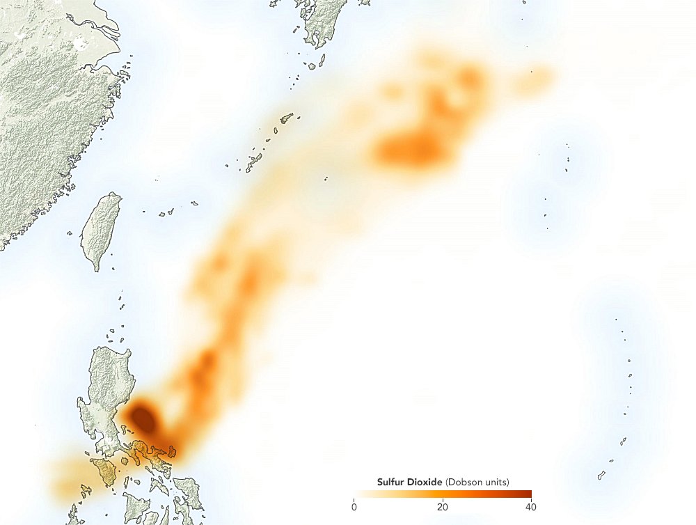 | |
| NOAA-NASA衛星「Suomi-NPP」の観測によるSO2の濃度分布(1月13日) |
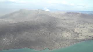 |
| The Taal Volcano up close(1/16 upload) |
NASAは16日衛星から観測した二酸化硫黄の分布図を公表しました。タール火山には火口湖がありましたから、初期のうちは火山灰も水でコーティングされた湿った粒子だったと思われますが、火口湖は既に消滅し、マグマ噴火に移行していますので、火山灰も恐らくこの図のように沖縄周辺海域まで到達しているのでしょう。
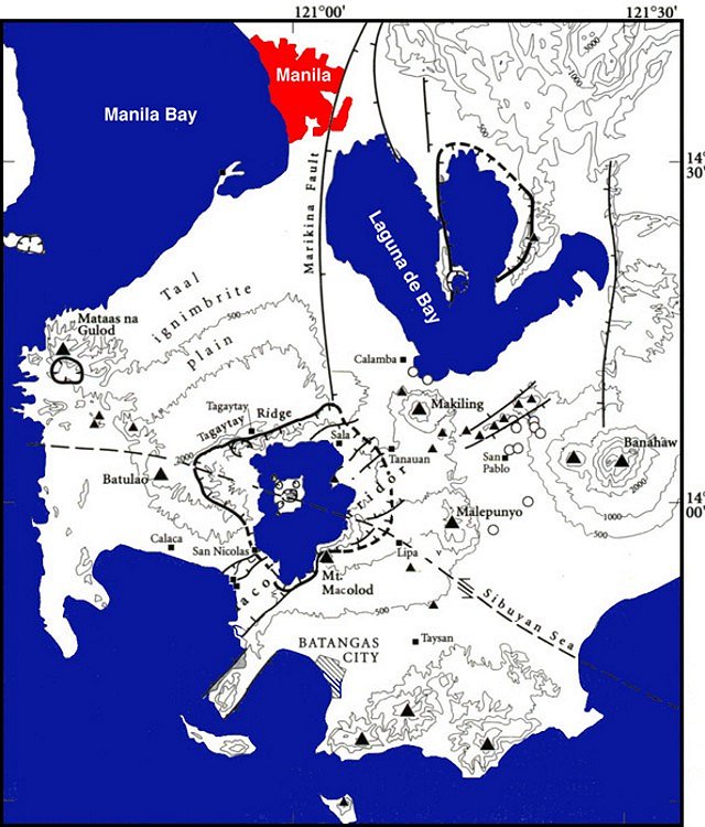
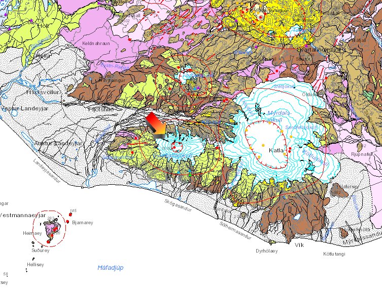
ちなみに桜島と鹿児島空港の距離は約30kmです(下記地質図の円は半径60km)。他人ごとではありません。
産総研東アジア地質図( :タール火山, :タール火山, :アキノ空港, :アキノ空港, :マニラ市役所) :マニラ市役所) | 産総研シームレス地質図(:桜島,:鹿児島空港,:鹿児島市役所) |
タール火山の地質と噴火史
 | 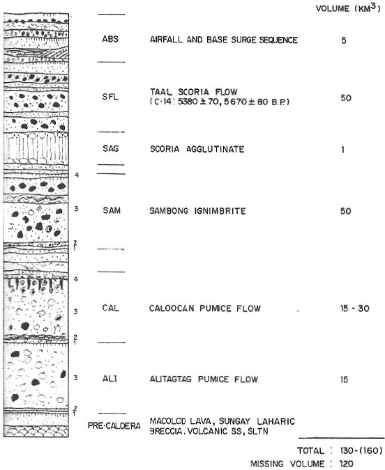 | 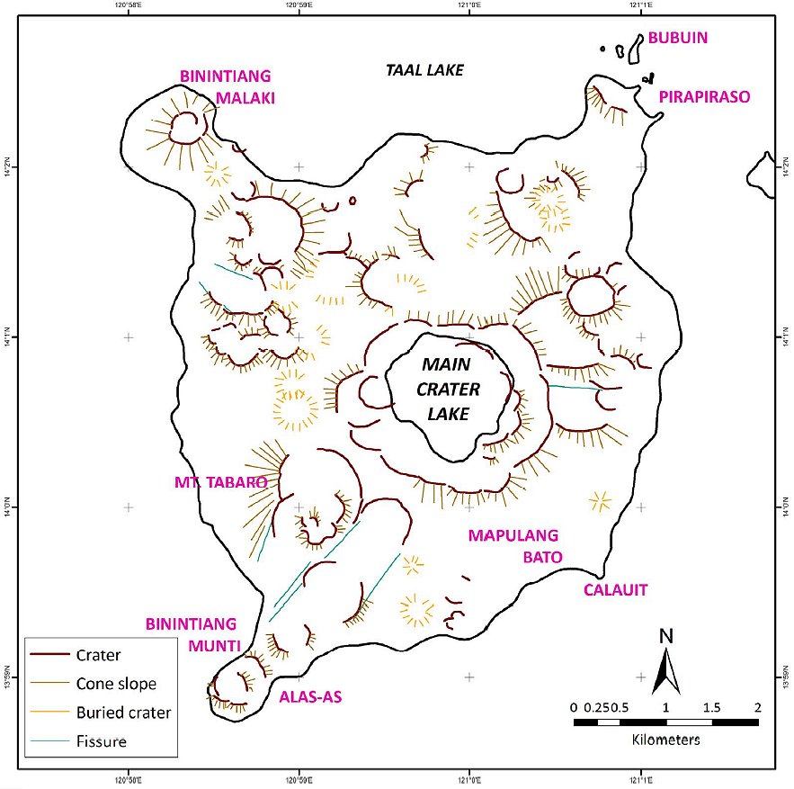 |
| Taal Caldera(Torres et al., 1995) after Smithsonian Inst. | Standard section of Taal Caldera (Listanco,1994) | Volcano Island(Reyes et al., 2018) |
<注> フィリピンの地質図を縮小してみてください。アメリカ地質調査所USGSによるプレート境界が表示されます。USGSの考えではルソン島をトランスフォーム断層が横断しているとしています。
アイスランド・エイヤフィヤトラヨークトル2010年噴火と航空障害
 |  |
| アイスランド地質図(凡例) 矢印:Eyjafjallajökull Volcano Iceland Geosurvey(ISOR)による | 4月14日から25日にかけての火山灰の雲を 合成した地図(赤丸は噴出源) (Wikipediaによる) |
航空機への火山灰の影響は、機体表面に付着して、微妙な重量バランスを崩すこと、速度計のピトー管を詰まらせること、エンジンに吸い込まれて融け、火山ガラスとなって付着することなどが考えられています。
蛇足ながらEyjafjallajökull火山の北東にあるLakagígar火山(英名Laki火山)の1783年噴火により、SO2を主体とする「ラキのもや」がヨーロッパ全土を覆い、その後数年間異常気象をもたらしました。この異常気象に伴う飢饉がフランス革命(1789)の原因の一つと言われています。
桜島大正噴火の降灰
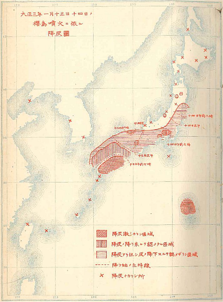 |
| 桜島大正噴火の降灰(気象要覧) |
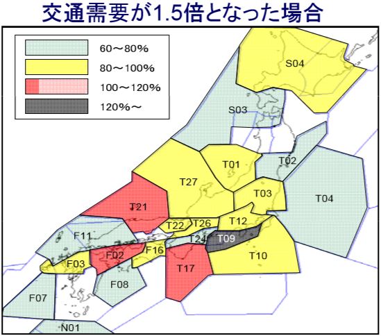 |
| 航空交通量増大と管制混雑(国交省) |
2020年は東京オリンピックで訪日客が激増するでしょうが、それ以降も訪日外国人の増加は予想されています。右図は空の混雑予想ですが、首都圏(成田・羽田)だけでなく、西日本の混雑が酷くなりそうとの予想です(T17:紀伊,T21:近畿西,FD2:中国南)。北米へ直行する便を除いてほとんどがこの空域を通るからです。那覇・仁川・北京・上海・台北・マニラ・シンガポールなどのハブ空港へ行くためにもこの空域を通らなければならないのが拍車をかけています。そこで、現在は札幌・東京・福岡・那覇の4管制部体制で航空管制を行っているのですが、上空10km以上の高高度全体を福岡で、10km以下の低高度のうち東日本を東京で、西日本を神戸で管制する3管制部体制に移行することにしているそうです。このような状況の中で桜島が噴火したらどうなるのでしょう。
文献
- Arpa, M. C. B., Patino, L. C. & Vogel, T. A.(2008), The basaltic to trachydacitic upper Diliman Tuff in Manila: Petrogenesis and comparison with deposits from Taal and Laguna Calderas. Jour. Volcanology Geothermai Res., Vol.177, Issue 4, p.1020-1034.
- Arpa, M. C., Hernández, P. A., Padrón, E., Reniva, P., Padilla, G. D., Bariso, E., Melián, G. V., Barrancos, J., Nolasco, D., Calvo, D., Pérez, N. M. & Solidum, R. U. Jr.(2013), Geochemical evidence of magma intrusion inferred from diffuse CO2 emissions and fumarole plume chemistry: the 2010–2011 volcanic unrest at Taal Volcano, Philippines. Bull. Volcanology, Vol.75, No.747, p.1-13.
- Bartel, B. A., Hamburger, M, W., Meertens, C. M., Lowry, A. R. & Corpuz, E.(2003), Dynamics of active magmatic and hydrothermal systems at Taal Volcano, Philippines, from continuous GPS measurements. Jour. Geophys. Res., Vol.108, No. B10, p.4-1 - 4-15.
- Bird, P.(2003), An updated digital model of plate boundaries. Geochemistry, geophysics, geosystems, Vol.4, No.3, p.1-52.
- Catane, S. G.,Taniguchi, H., Goto, A., Givero, A. P. & Mandanas, A. A.(2005), Explosive volcanism in the Philippines. CNEAS Monograph Series No.18, Tohoku Univ., pp.
- 中央気象台(1914), 気象要覧, 臨時増刊 No.170, 16pp.
- EOS(2010), Aircraft and Volcanic Ash - a Key Focus of EGU Meeting. EOS, Vol.91, No.21, p.191.
- Kvizda, M. & Seidenglanz, D.(2014), Out of Prague: a week-long intermodal shift from air to rail transport after Iceland’s Eyjafjallajökull erupted in 2010. Jour. Transport Geography, Vol.37, No., p.102-111.
- Langmann, B., Folch, A., Hensch, M. & Matthias, V.(2012), Volcanic ash over Europe during the eruption of Eyjafjallajökull on Iceland, April–May 2010. Atmospheric environment, Vol.48, No., p.1-8.
- Listanco, E. L.(1994), Space-time patterns in the geologic and magmatic evolution of calderas : a case study at Taal Volcano, Philippines. 東京大学学位論文.
- Martinez, M.M.L. and Williams, S.N.(1999), Basaltic andesite scoria flow deposits from Taal Caldera, Philippines. Jour. Geol. Soc. Philippines, Vol.54, No.12, p.1-18.
- Mastin, L. G. & Witter, J. B.(2000), The hazards of eruptions through lakes and seawater. Jour. Volcanology and Geothermal Research, Vol.97, Issue 1-4, p.195-214.
- Mines and Geosciences Bureau, Philippines(2010), Geology of the Philippines. MGB Philippines, pp.
- Moore, J. G., Nakamura, K. & Alcaraz, A.(1966), The 1965 eruption of Taal volcano. Science, Vol.151, Issue 3713, p.955–960.
- 中村一明(1966), タール火山1965年の岩漿性水蒸気爆発. 地学雑誌, Vol.75, No.2, p.93-104. 口絵
- Oppenheimer, C.(1991), People and volcanoes: Taal Island, Philippines. Geology Today, Vol., No., p..
- Ramos, E. G.(2002), Origin and geologic features of Taal Lake, Philippines. Aquatic Ecosystem Health and Management, Vol.5, No.2, p.155-162.
- Reyes, P. J. D., Bornas, M. A. V., Dominey-Howes, D., Pidlaoan, A. C., Magill, C. R. & Solidum, R. U. Jr.(2018), A synthesis and review of historical eruptions at Taal Volcano, Southern Luzon, Philippines. Earth-science reviews, Vol.177, No., p.565-588.
- Sigmundsson, F., Hreinsdóttir, S., Hooper, A., Árnadóttir, T., Pedersen, R., Roberts, M. J., Óskarsson, N., Auriac, A., Decriem, J., Einarsson, P., Geirsson, H., Hensch, M., Ófeigsson, B. G., Sturkell, E., Sveinbjörnsson, H. & Feigl, K. L.(2010), Intrusion triggering of the 2010 Eyjafjallajökull explosive eruption. Nature, Vol.468, No., p.426-430.
- Torres, R. C., Self, S. & Punongbayan, R. S.(1995), Attention focuses on Taal: Decade volcano of the Philippines. EOS, Vol.76, Issue 24, p.241-247.
- Volcanol. Soc. Japan(2003), IUGG 2003 Field Trip Guidebook. pp.
- Yamaya, Y., Alanis, P. K. B., Takeuchi, A., Cordon, J. M. Jr., Mogi, T., Hashimoto, T., Sasai, Y. & Nagao, T.(2013), A large hydrothermal reservoir beneath Taal Volcano (Philippines) revealed by magnetotelluric resistivity survey: 2D resistivity modeling. Bull. Volcanology, Vol.75, No.729, p.1-13.
- You, S. -H., Gung, Y., Lin, C. -H., Konstantinou, K. I., Chang, T. -M., Chang, E. T. Y. & Solidu, R.(2013), A preliminary seismic study of Taal Volcano, Luzon Island Philippines. Jour. Asian Earth Sciences, Vol.65, No., p.100-106.
- (), . , Vol., No., p..
- (), . , Vol., No., p..
- (), . , Vol., No., p..
- (), . , Vol., No., p..
参考サイト:
- Philippine Institute of Volcanology and Seismology, Department of Science and Technology(PHIVOLCS)(火山・地震研究所)
- Volcanoes of the Philippines
- Taal Volcano
- General Location of Fissures Related to the January 2020 Taal Volcano Eruptive Activity (as of 18 January 2020)
- This serves as a notice for the lowering of Taal Volcano’s status from Alert Level 4 (hazardous eruption imminent) to Alert Level 3 (decreased tendency towards hazardous eruption)(TAAL VOLCANO BULLETIN 26 January 2020 8:00 AM)
- Hzard Hunter PH
- GeoRisk PH(Geospatial Information Management and Analysis Project for Hazards and Risk Assessment in the Philippines)
- National Disaster Risk Reduction and Management Council(NDRRMC)(国家災害リスク軽減管理評議会)
- Mines and Geosciences Bureau, Department of Environment and Natural Resources(MGB)(鉱山地球科学局)
- National Mapping and Resource Information Authority, Department of Environment and Natural Resources(NAMRIA)(フィリピン国土地理院)
- Global Volcanism Program(Smithsonian Institution)
- Volcano Discovery
- Volcano Island of Taal(NASA Earth Observatory)
- Sulfur Spews from Taal(NASA Earth Observatory)
- Volcano Global Risk Identification and Analysis Project (VOGRIPA) (BGS & Bristol Univ.)
- Tectonics and Volcanoes of the Philippines(Volcano World: Oregon State University)
- Geological map of the Philippines(National Library of Australia)
- Volcanic ash disruption leaves Britons stranded(BBC News)
- Hike Taal Volcano
- Dr. Mahar Lagmayの解説動画(facebook)
- Nighttime Landsat 8 image of the Taal Volcano(USGS)
- 2020年1月12日フィリピン・タール火山の噴火に伴う地殻変動(国土地理院)
- 地震のページ(石川有三氏)
- 将来の航空交通システムに関する推進協議会(国交省)
- 将来の航空交通システムに関する研究会(国交省)
- 参考資料(国交省)
- 航空保安システムの現状について(国交省)
- ATMセンター(航空局 航空局管制保安部)
- Taal Volcano Eruption Snapshot 31 Jan 2020(国際連合人道問題調整事務所 United Nations Office for the Coordination of Humanitarian Affairs OCHA)
- Geology Map by ISOR(Iceland Geosurvey)
- ()
- ()
- ()
- ()

初出日:2020/01/12
更新日:2020/03/27