 Sorry! Wait a moment, please.
Introduction|Contents|Subsurface Geology of Kagoshima Plain|Contour Map of the Base Level of the Alluvium|Hazard Map of Liquifaction Disaster
 Introduction
The heavily damaged belt zone(JMA Intensity VII or greater) by Kobe earthquake of 1995 was identified near the earthquake fault and it became famous that the zone corresponds to soft ground. It was again shown that the importance of the ground condition at any site whether ground disaster reduction is to be considered or ground developments of water-/geo-front are to be planned.
A joint research work among our laboratory, professors at the faculty of agriculture and engineering, and the association of geological boring companies in Kagoshima was planned at the Regional Cooperative Center of Kagoshima University. We have developed a boring data base system in Kagoshima city which contains more than 2,000 boring logs.
The new analysis based upon the large number of these data have completely revised the existing ground map(1969, ministry of construction). The results are compiled as "Subsurface Geological Map of Kagoshima City"(131 pages and two figures, size A3) published by Tokudaya book store.
Tokudaya book storeÅG
4-21 Higashi Sengoku-cho, Kagoshima-city 892 Japan
(phone+81-99-222-3264)
Contents
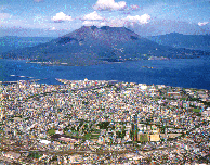 Central part of Kagoshima city and our campus(237KB)
The contents of the book is as follows,
- Introduction
- Topography
- General Geology
- Subsurface Geology due to Some boring Data
- Geological Structure
- Historical Geology
- N-value
- Physical Properties of the Sediments
- Mechanical Properties of the Sediments
- Liquifaction of Sandy Sediments
- Groundwater
Appendix:
Contour Map of the Base Level of the Alluvium
Surfacial Geological Map of Kagoshima City
Subsurface Geology of Kagoshima Plain
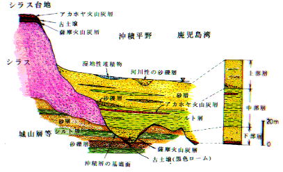 Schematic Cross Section (Yokota, 1995)
In Kagoshima-plain, a wide spread dense sand and/or gravel layer is found at a few tens meters in depth from the surface. This layer is known as Shiroyama formation which was deposited about 13,000 years BP(before present) or Kokubu formation(older than Shiroyama formation).
Above this sand/gravel layer, Shirasu(a local term for pumice deposit in Kagoshima area; shira comes from shiro(white) and su comes from suna(sand); shira+su=white sand) layer was deposited some 24,000 years ago. These Shiroyama/Kokubu and When sea level became lower(about 150m lower than the present sea level) during the last glacial age(Wuerm(about 20,000 BP)), Shirasu formations were appeared on the surface and eroded resulting in several rivers and deep valleys in this plain. After the glacial age, the weather on the earth became warmer and the sea water risen world wide to about 40m lower than the present level during the Late Pleistocene and Holocene in geological age. This is called Alleroed interstadial.
Contour Map of the Base Level of the Alluvium
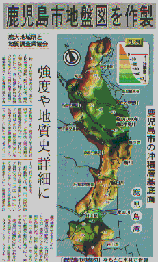 Basement Lvel of the Alluvium(The Minami-Nihon)
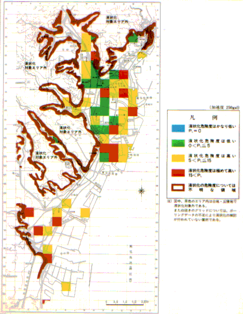
Hazard Map of Liquifaction Disaster
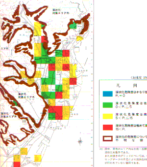 Hazard Map of Liquifaction /Disaster
Top of the Page|Introduction|Contents|Subsurface Geology of Kagoshima Plain|Contour Map of the Base Level of the Alluvium|Hazard Map of Liquifaction Disaster
- Home Page of Applied Geology
- Contents of Applied Geology WWW
- List of Linked WWW on Earth Sciences
- WWW Servers in Japan
E-mail: iwamatsu@sci.kagoshima-u.ac.jp
Update: January 27, 1997
 Subsurface Geological Map of Kagoshima City
 Central part of Kagoshima city and our campus(237KB)
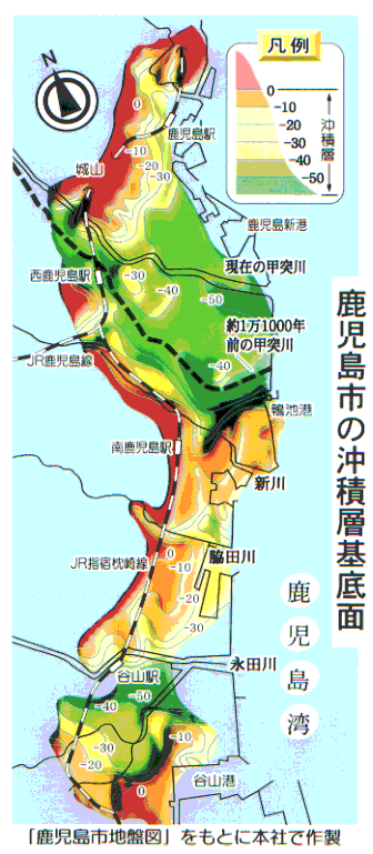 Basement Lvel of the Alluvium(The Minami-Nihon)
 Hazard Map of Liquifaction /Disaster